
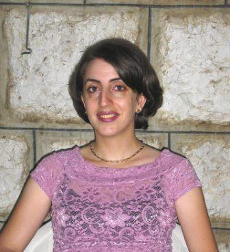
Dr. Rania Bou Kheir
As of 2008
 Miss
Rania Bou Kheir was born in Lebanon in 1974, has a long experience in
research, having spent around 10 years at the National Council for Scientific
Research/National Center for Remote Sensing (NCRS) in Lebanon, working and
cooperating in national and international development projects, and involved in
scientific publishing related to soil and land management problems
(e.g., water erosion, soil pollution, desertification, land
degradation, mass movements, forest fires, etc.). She holds an engineering
diploma in Agriculture engineering from the Lebanese University (1997), a MSc.
from the academic agency of French speaking-countries (Lebanon) in 1998, and a
PhD (highly honorable with congratulations of the committee) in the
application of remote sensing and GIS (Geographic Information Systems) for
modeling land degradation problems from Institut National Agronomique Paris-Grignon
(France) in 2002.
Miss
Rania Bou Kheir was born in Lebanon in 1974, has a long experience in
research, having spent around 10 years at the National Council for Scientific
Research/National Center for Remote Sensing (NCRS) in Lebanon, working and
cooperating in national and international development projects, and involved in
scientific publishing related to soil and land management problems
(e.g., water erosion, soil pollution, desertification, land
degradation, mass movements, forest fires, etc.). She holds an engineering
diploma in Agriculture engineering from the Lebanese University (1997), a MSc.
from the academic agency of French speaking-countries (Lebanon) in 1998, and a
PhD (highly honorable with congratulations of the committee) in the
application of remote sensing and GIS (Geographic Information Systems) for
modeling land degradation problems from Institut National Agronomique Paris-Grignon
(France) in 2002.
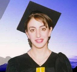
Recently (July 2007), she got
the “Accreditation to supervise research” diploma [Habilitation à diriger des
recherches (HDR)] from the University of Pierre and Marie Curie Paris 6,
evaluating her status as a professional researcher and assigned her the rank of
full professor. She did a postdoctoral research (2004) at the University of
Southern California USC (GIS research laboratory) beneficiating from a USA
Fulbright scholarship.
 This
research pertains to modeling soil-erosion using optical image sensors and GIS
thematic data. In addition to her work in the research domain, she is instructor
(since 2002) at several universities in Lebanon, i.e. Notre-Dame University,
Holy-Spirit University (Kaslik), Saint-Joseph University and Lebanese
University, covering undergraduate and graduate courses of an interdisciplinary
nature in both languages French and English (e.g.,
environmental geology, soil science, geography and agrometeorology, theories of
remote sensing, interpretation of satellite imageries, principles and
applications of GIS). She supervised two PhD students registered at
University of Bordeaux 1 and University of Paris VI (France), and several master
and engineering students in Lebanon.
This
research pertains to modeling soil-erosion using optical image sensors and GIS
thematic data. In addition to her work in the research domain, she is instructor
(since 2002) at several universities in Lebanon, i.e. Notre-Dame University,
Holy-Spirit University (Kaslik), Saint-Joseph University and Lebanese
University, covering undergraduate and graduate courses of an interdisciplinary
nature in both languages French and English (e.g.,
environmental geology, soil science, geography and agrometeorology, theories of
remote sensing, interpretation of satellite imageries, principles and
applications of GIS). She supervised two PhD students registered at
University of Bordeaux 1 and University of Paris VI (France), and several master
and engineering students in Lebanon.
As of October 2007, she authored
and co-authored 25 scientific papers in peer-reviewed international scientific
journals, 30 papers in international and national conferences, and participates
in books and scientific reports editing. She received several honors and awards
(e.g., «J. William Fulbright» award from the Council
for International Exchange of Scholars (CIES) – Washington (July 2004), «Great
Women of the 21st Century – Environmental Sciences» award from
the American Biographical Institute (August 2005), Marie-Curie
scholarship/European commission (April 2006),
the 10th Anniversary of
Franco-Lebanese CÈDRE program award for good research and publications (June
2006)].
Contact:
prof.boukheir at gmail
(in code to minimize spamming)
Previous expertise
She has
extensive experience in the coordination and participation in international
projects in the area of remote sensing and GIS environmental modelling (erosion,
pollution, land use changes, mass movements, forest fires, etc.), including the
coordination of AUF, CÈDRE and SIDA projects (held with France, Tunisia and
Sweden), and the participation in the European MEDCOASTLAND project which
combines 36 research institutions in 12 countries, EU Life programs [COLD (www.coldproject.net/),
ResManMed (www.environmentalmalta.com)
including 9 countries], UNEP, FAO and ASCAD projects.
Selected publications
Abdallah, C., Chorowicz, J., Bou Kheir, R., Khawlie,
M., 2005. Detecting major terrain parameters relating to mass movements'
occurrence using GIS, remote sensing and statistical correlations, case study
Lebanon. Remote Sensing of Environment, 99, 448-461.
Abdallah, C., Chorowicz, J., Bou Kheir, R.,
Dhont, D., 2007. Comparative use of processed satellite images in remote sensing
of mass movements: Lebanon as a case study.
International Journal for Remote Sensing,
under press.
ACSAD-GTZ, 2005. Desertification Assessment and
Monitoring System (DAMS). ACSAD (Arab Center for the
studies of Arid Zones and Dry Lands) (Syria) and GTZ (Gesellschraft fur
Technische Zusammenarbeit) (Germany), 50p.
Bou Kheir, R., Girard, M-C., Shaban, A., Khawlie, M., Faour, G.,
Darwish, T., 2001. Apport de la télédétection pour la
modélisation de l’érosion hydrique des sols dans la région côtière du Liban.
Télédétection, 2(2),
79-90.
Bou Kheir, R.,
Shaban, A., Girard, M-C., Khawlie, M., 2001. Impact des
activités humaines sur l’érosion hydrique des sols dans la région côtière
montagneuse du Liban. Sécheresse, 12(3), 157-165.
Bou Kheir, R., Girard, M-C.,
Khawlie, M., 2004. Utilisation d'une classification structurale OASIS pour la
cartographie d'unités de paysage dans une région représentative du Liban.
Canadian Journal of Remote Sensing, 30(4), 617-630.
Bou Kheir, R., 2006.
Etude de l’efficacité de l’intégration de la capacité d’infiltration des roches
affleurantes dans les modèles spatialisés d’érosion en utilisant la
télédétection et le SIG – exemple au Liban. Photo-interprétation,
1, 19-26.
Bou Kheir, R.,
2006. Managing soil erosion risk using GIS and Remote Sensing, case study
Lebanon. 18th International Soil Meeting (ISM) on Soils Sustaining
Life on Earth Managing Soil Science and Technology. Soil Science Society of
Turkey and Harran University, Sanliurfa, Turkey, 22-26/5/2006, 431-437.
Bou Kheir, R.,
Wilson, J. 2006. Use of DEMs for predictive gully soil-erosion mapping in
Lebanon. 18th World Congress of Soil Science, USA, 9-15/7/2006,
Philadelphia, Pennsylvania, USA.
Bou Kheir, R.,
Abdallah, C. 2006. Conceptualization of GIS field prediction regional
soil-erosion Mediterranean models, case study Lebanon. European General Assembly
(EGU), 2-9/4/2006, Vienna, Austria. Geophysical Research Abstracts, European
Geosciences Union, vol. 8, 01289, 2006, SRef-ID: EGU06-A-01289.
Bou Kheir, R.,
Runnstrom, M., Martensson, U. 2006. Definition of landscape erosion units using
a structural classification OASIS of Landsat TM satellite imageries, case study
Lebanon. 6th AARSE International Conference on Earth Observation &
Geoinformation Sciences in Support Africa’s Development, National Authority for
Remote Sensing and Space Sciences (NARSS) and African Association of Remote
Sensing of the Environment (AARSE), Cairo, Egypt, 30/10-2/112006, 164-165.
Bou Kheir, R.,
Chorowicz, J., Abdallah, C., Dhont, D., 2006. Impact of
torrential rainfall on gully erosion in Lebanon: use of decision-tree model to
map soft lands. Young Scientist’s Global change conference, Earth System Science
Partnership, 9-12/11/2006, Beijing, China, 8 p.
Bou Kheir, R.,
Cerdan, O., Abdallah, C., 2006. Regional soil erosion risk assessment in
Lebanon. Geomorphology, 82, 347-359.
Bou Kheir, R., Cerdan, O., Girard, M-C., Abdallah, C., 2007.
Importance de la prise en compte du MNA dans les trois
dimensions pour la cartographie du potentiel de ruissellement, application au
Liban. Zeitschrift fur Geomorphologie,
51(2).
Bou Kheir, R., Wilson, J., Deng, Y., 2007. Use
of terrain variables for predictive gully erosion mapping in Lebanon.
Earth Surface Processes and Landforms, under press.
Bou Kheir, R., Chorowicz,
J., Abdallah, C., Damien, D., 2007. Soil and bedrock distribution estimated from
gully form and frequency: a GIS-based decision-tree model for Lebanon.
Geomorphology, under press.
Faour, G., Bou Kheir, R., Darwish,
A., 2006. Méthode globale d’évaluation du risque
d’incendies de forêt utilisant la télédétection et les SIG : cas du Liban.
Télédétection, 5(4), 359-377.
GLA-AFDC, 2005. Forest fire fighting in Lebanon using remote
sensing and GIS. Green Line Association (Liban), Association for Forest
Development and Conservation (AFDC) (Liban) and European Commission (programme
Life), 161p.
GTZ, 2007. Desertification monitoring and assessment (DMA) in the Arab World
using satellite imageries between 1982 and 2005. Deutsche
Gesellschraft fur Technische Zusammenarbeit GTZ (Germany), 15p.
Khawlie, M., Awad, M., Shaban, A., Bou Kheir, R., Abdallah, C.,
2002. Remote sensing for environmental protection of the eastern Mediterranean
rugged mountainous areas, Lebanon. ISPRS Journal of Photogrammetry & Remote
Sensing, 57, 13-23.
PAP/RAC-UNEP, 2004. Improving coastal land degradation
monitoring in Lebanon and Syria – Country report: Lebanon. Descriptive erosion
mapping, Identification and prioritization of future intervention areas, Draft
management program. European commission, LIFE program, TCY/00/INT/00069/MED. ERS/RAC,
138p.
UNEP-FAO, 2000. Guidelines for erosion and
desertification control management with particular reference to Mediterranean
coastal areas. UNEP (United Nations Environment Programme) – Mediterranean
Action Plan, priority actions programme in cooperation with FAO. European
commission, 108p.
************************************
Dr. Rania Bou Kheir is
interested in collaborating with other researchers from Lebanon and all over the
world on international projects and scientific publishing.
From Shweir old Bulletin
Board

|
Author |
Topic:
Interviews with old people from Shweir |
Waleed Moujaes
Member |
 posted
03-10-2001 08:18 PM posted
03-10-2001 08:18 PM 

I have copied this from alanwar.com today. I don't know if you
can read it. Those are 3 interviews which Alanwar newspaper did
with 3 elderly people from Shweir, Farid Aoun Moujaes, Nasib
Touma Sawaya and Mary Nasr Khneiser ( Em Atef); I forgot her
husbands name. If somebody can translate, it will be great and
interesting.
فريد مجاعص: امرني الشيخ خليل عون ان اتزوج وديعة..
ففعلت
من ذاكرتهم تندفع ذكريات تعود بهم الى ماضيهم البعيد وصباهم
ونشاطهم في أيام العز، فيروون ما يتذكرون وكأنهم يعيشون اللحظة بكل
ما فيها من أحاسيس وانفعالات.
في ضهور الشوير، كان لقاء مع ثلاثة مسنين تسعينيين من البلدة التي
تحتضن 12 مسناً تتراوح أعمارهم بين 85 و95 عاماً.
فريد عون مجاعص عمره 94 عاماً يتمتع بصحة جيدة ويعيش مع زوجته في
منزل ابنته وعائلتها. قال: (تعلمت سنتين في المدرسة الاميركية، ولم
استطع متابعة تعليمي لاني كنت مسؤولاً عن عائلة فاضطررت للعمل.
تزوجت سنة 1935 وعندي أربعة اولاد وقد عملت جابي ضرائب في البلدية
لمدة 63 عاماً. إبان الحرب الاولى كان الناس يموتون جوعاً ويأكلون
قشر الليمون ويغلون دم الخراف ويشربونه. كنا بالكاد نحصل على
القليل، فنعمد الى السرقة. مرة نشلت قطعة لحم من امرأة فضربتني
بالسكين، ومازالت الندبة في ظهري حتى اليوم.
في حرب الـ 14، عندما أتت إعاشات القمح من زحلة الى ضهور الشوير،
كنا نكيلها بـ (القحف) فنعطي كل شخص قحفين. وحين زار ديغول البلدة
استقبلناه بالهتاف ولم استطع ان اقول له شيئاً. فهذا الجنرال ديغول!
قضيت حياتي في الشوير وضهور الشوير وعندي ارض كنت أزرعها وأهتم بها،
لكني مؤخراً لم أعد قادراً على ذلك. كنا نسهر في الأمسيات، ونعمل
المعكرون زليط المعجون بالدبس. وفي الصيف كنا نجتمع على العين لعصر
العنب وعمل الدبس فنشوي البصل والبطاطا. كنانقوم برذالات كثيرة في
صبانا فنراشق البيوت ليلاً بالحجارة، واذا مرت فتاة نرمي وراءها
أشياء.
أحببت امرأة متزوجة وأردت أن أخذها من زوجها فأصبحت عاشقاً ولا
أعود الى المنزل قبل الفجر. فقالت لي أمي أنها تريد أن تزوجني
وأمرني الشيخ خليل عون، وهو كان صاحب نفوذ، بأن اتزوج وديعة (زوجته)
فكان ذلك. وألبستها قبعة ومعطفاً من عند أبي راشد في باب ادريس،
وكانت جميلة جداً. واليوم عندما أذهب الى الكنيسة أسلم على السيدات
وأهنئهن على أصواتهن الجميلة، وأقبلهن وطبعاً ذلك عن طيب نية.
تعلمت القيادة لوحدي فكنت أتمرن الى الخلف والأمام و(ديمي تور)
وبعدها صرت أذهب الى المدينة. ومرة اصطحبت معي فتاة فوقعنا تحت
حافة الطريق. ووصل الخبر الى والدها بأني اختطفتها أنا تكسرت أضلعي
وهي أخذت تصرخ (أخ ظهري) ومكثنا في بحنّس أربعة اسابيع.
كنت أحضر في السينما أفلام عبد الوهاب وأم كلثوم. وعام 1932 ذهبت
على الموتوسيكل لأحضر في أوتيل الروضة حفلة لعبد الوهاب حين غنى (يا
جارة الوادي) وصفقنا له كثيراً. يومها كان يعتمر الطربوش ويدق على
العود ولم يرضَ إلا بأن يقبض نقوده فوراً).
يضيف (كنت أنبه الزعيم انطوان سعادة وزملاءه عند حصول كبسات كي
يهربوا من وجه العدالة. كنا نحضر المياه للزعيم من عين البستان كي
يستحم. وهو كان يحضر لنا الطعام فنأكل معه وبعد أن ننتهي يقول لنا
(الى الانصراف) ويضع الكتاب تحت إبطه ويذهب الى العرزال في مطل
الدير.
وقال: كانت تحصل كبسات مفاجئة، فمّرة كان الزعيم عندنا مع زوجته
وأولاده، وجاء سائق (المكنة) وأخبره انه مطلوب. عندها وصل جورج عبد
المسيح وقال له (تحيا) فأجابه (تحيا أنت) وهربا معاً الى مطل الدير.
وعندما كان يأتي الضابط في (المكنة) كان يوقفني على رفرافها كي
أدله على منازل الذين يخصون الزعيم ايضاً).
عشت كثيراً لان صحتي جيدة ودمي نظيف، فقد أجريت لي عملية جراحية
وظل جرحي ينزف لمدة سنة ونصف السنة فاشتريت وقية بقلاوة وأكلتها
فشفيت. وكان الطبيب قد قال لي حينها أني سأعيش عشر سنوات فقط بعد
العملية، وها أنا اليوم حي أرزق، وهو قد توفي منذ زمن طويل. كما أن
المشي ضروري جداً وانا اذهب مع ابنتي أيام السبت الى كنيسة مار
جرجس والأحد الى كنيسة السيدة، سيراً على الأقدام).
المنزل الذي يعيش فيه فريد عون يطل على الدار التي ولد فيها عاصي
الرحباني، فروى بعض ما يتذكره عنه: (كان عاصي الرحباني يملك مقهى
ويشتري له البطيخ والطعام وكنا نساعده في ذلك، وكان يخاف الحيّات
كثيراً. وفي احدى المرات وضعنا حبلاً أسود، وعندما خرج عاصي شدينا
الحبل فخاف وهرب تاركاً الطعام فأكلناه).
نسيب صوايا: احتلينا مطاعم البرج عام 1931
احتجاجاً على البطالة
المعمر نسيب صوايا عمره 94 سنة ويعاني من نشاف في أذنيه ما يجعل
سمعه صعباً جداً. قال (عام 1914 بدأت الحرب وشاركت بها المانيا
وحدها فلم يتضايق لبنان. لكن عندما دخلتها تركيا عام 1916، سكّر
البحر. ولبنان بحدوده من البترون الى صيدا ومن البحر الى معلقة
زحلةكان تحت حماية الدول السبع وكانت بيروت وسهل البقاع ولايتين
تابعتين لسوريا. فاذا اخذنا البضائع الى بيروت كان يجب أن ندفع رسم
دخول. كان لوالدي من زواجه الاول ابنان سافرا الى اميركا، ونحن كنا
سبعة من زواجه الثاني. عند وفاته عام 1916، اصطحبتني أمي الى بيروت
وقالت لي إذا جار عليك الزمن، لا تسكن الا المدن. فقصدنا دير
الناصرة حيث طلبت احدى الراهبات من أمي العمل في مأوى تشرف عليه
السيدة ليندا سرسق ومدام أصفر ومدام صباغ.
وفي تلك الفترة ضربنا جوع لا مثيل له، فكانت بلدية بيروت تلم
الموتى بالجملة عن جوانب الطرقات. وفي احد الايام رأت السيدة ليندا
سرسق فتاة مرمية في الشارع وتكاد تموت فأحضرتها الى المأوى حيث
اهتمت بها والدتي. وبعد فترة أرادت سرسق الاطمئنان على الفتاة،
وحين رأتها بحالة جيدة شكرت أمي، ومكافأة لها أحضرت اخوتي الى
المأوى وهكذا أراد الله ان يرزق عباده.
ومرة زار جمال باشا الجزار المأوى فأنشد له أخي أغنية تركية فتساءل
الجزار: انا اسمع صوت فتى وأرى لباس بنت. وكنا نرتدي صبياناً
وفتيات القنابيز بسبب الفقر. يومها أحضر كتاناً المانياً اصفر
اللون وخاطوا لنا البذلات ومن يومها صرنا نلبس اللباس (الافرنجي).
عام 1918 دخل الإنكليز والفرنسيون من طرابلس فتم نقلنا الى
اليسوعية في غزير حيث مكثنا بضع سنوات الى أن أرسل اخواي المسافران
المال فعدنا الى البلدة. وقد عملت في معمل الدخان الذي كان في
المنطقة والذي كانت يومية العامل فيه 40 قرشاً والمعلم 60 قرشاً.
حينها كانت المئة ليرة تؤمن معيشة عائلة لمدة شهر، فكل شيء كان
رخيصاً. أقفل المعمل عام 1932 فتضايقت مادياً إذ أنني كنت قد تزوجت
عام 1929 ورزقت ابني فريد عام .1931 كما أنني لم أكن أتقن اي مهنة
أخرى لأن المعمل أخذ كل وقتي. فجمعنا ست باصات وقصدنا البطريرك
عريضة الذي أكد لنا ان البرقيات التي يرسلها لا تصل، ونصحنا بأن
نقاطع الدخان فنتوقف عن التدخين. وهكذا نعاقبهم ونحاربهم. لكننا لم
نقتنع بذلك، فذهبنا الى ساحة البرج واحتلينا المطاعم لنفتعل
المشاكل فيشتكي أصحابها الا أنهم لم يفعلوا حتى بعد أن رجوناهم.
وطلب رؤيتنا الكونت دي مارتيل من حزب العمال الفرنسي، فزرناه وكنا
أربعة نمثل خمسة آلاف عامل ومعنا المحامي ميشال قشعمي من بكفيا
ليتحدث معه بالفرنسية. واعترضنا على استبدالنا بالآلات، فقال لنا
الكونت: هل أقول لسكة الحديد ان تتوقف عن العمل كي يشتغل المكاري?
فأجبته فوراً: اذا كنا سنموت فلن نموت جوعاً نحن وأولادنا بل
الافضل ان نموت برصاص جنودنا. عندها ضحك ووعدنا بشرف فرنسا بأن
يصون حقوق العامل ويساعدنا. من ثم أنشئ في بكفيا معمل للف الدخان
يدوياً. الا اننا بدل أن نقبض نصف ليرة على كل ألف سيجارة، اعطونا
16 قرشاً فتركت العمل، وتحولت الى تكسير الحجارة.
ومرة كنت أعمل في احدى الورش وبعد ان انهكني التعب من تكسير البحص
طوال اليوم، جاء رئيس العمال وقال لي الحجارة كبيرة. فصرت ألعب
القمار واغتنيت. حتى عينت عام 1938 حارساً في البلدية. أذكر أن احد
ابناء البلدة الشاعر والمؤلف جريس رستم كان له ولدان هما سعد وأسد.
وفي صباح احد الايام أزعجه الولدان بلعبهما وضجيجهما فقال لهما:
كفّا عن اللعب والمزاح اقلقتماني في مساي والصباح لو صيغ لي ذبح
البنين ذبحتكما.
فقاطعه أحدهما مكملاً: حرقت دين أبيكما الذبّاح.
وختم صوايا بالقول (انا لا أشارك في الاجتماعات ولا ازور احداً
بسبب سمعي الضعيف. وحالياً ان اسعى لشراء سماعات للأذنين.
ماري خنيصر:
حماتي احبتني عندما عجزت واصبحت بحاجة لي
وفي أحد أروقة البلدة، كانت ماري نصر خنيصر (ام عاطف) (95 عاماً)،
تتنزه مستندة الى عصاها وبدت في كامل صحتها. (أحببنا بعضنا أنا
وزوجي لفترة طويلة وكنا نرى بعضنا دائماً لانه جاري. تزوجنا في
البيت اذ ان هذا كان شائعاً في تلك الفترة ولم أرتد فستان عرس لأني
أذكر انه كان هناك حزن في العائلة. انتظرنا سنوات عديدة قبل ان
نتزوج لأن زوجي كان ينتظر زواج أخيه الذي كان (شرساً جداً).
وتتابع ضاحكة: (حماتي أحبتني حين أصبحت عاجزة وصارت بحاجة لي كي
أخدمها. وهي كانت تسبب لي مشاكل كثيرة لانها أرادت ان تزوج شقيق
زوجي وليس هو. حين كان زوجي يسافر الى قطر كنت أكتب له الرسائل،
اليوم نسيت الكتابة وأقرأ بصعوبة كبيرة).
ورنمت (أم عاطف) أغنية تركية: (حفظتها من اخواتي اللواتي تعلمن هنا
في مدرسة للأتراك لكني لا اعرف ماذا تعنيه هذه الأغنية).
في حرب الـ 14 هربنا على ظهر البغال الى زحلة، ومنها الى حمص ثم
الى مشتى بيت الحلو حيث بقينا خمس سنوات حتى انتهاء الحرب).
واضافت: (الحياة اليوم أحسن مما كانت في الماضي. لأننا كنا نعاني
الضيق والغلاء والفقر. فقد كنا ست بنات في نفس المنزل وكانت أمي
تخيط ثيابنا وتصلح فستان هذه لتلبسه لتلك. لكننا كنا نحب بعضنا
كثيراً ولم نكن نختلف. أما أخواتي فقد ماتت منهن ثلاثة هن اكبر مني
سناً وبقيت مع اثنتين أصغر مني).
Google Translation Feb 6, 2011
Fred Mjaas:
Sheikh Khalil Aoun ordered me to marry a deposit .. I
did
Memories of the memories rush back to their past and Remote
Bbahm and activity in the old days, what Viruon remember as if
they were living the moment with all their feelings and
emotions.
In Dhour Shweir, had a meeting with three elderly Tsainyen of
the town, which includes the 12 elderly aged between 85 and 95
years.
Fred Aun Mjaas 94-year-old in good health and lives with his
wife at the home of his daughter and her family. He
said: (I learned two years in the American school, I could not
follow-up tutorial because I was responsible for the family so I
had to work.
She married in 1935 and I have four children have worked in the
municipal tax collector for 63 years.During the first
war, people were dying of hunger and eating lemon peel and boil
and drink the blood of sheep. We
barely get a little, Venmay to theft. Nclt
time a piece of meat from a woman Vdharptni knife, and still
scar in my back until today.
In the war of 14, when it came Iashat wheat from Zahle to Dhour
Shweir, we Nkilha b (skull) Venattiy everyone Qahvin. When
de Gaulle visited the town Astqublnah yelling I could not tell
him anything. This is
General de Gaulle!
I spent my life in Choueir and Dhour Shweir and I have the land
you cultivate and care for them, but I recently was no longer
able to do that. We
lie awake in the evenings, and we are working Macaroon Zlait
Baldbs putty. In the
summer we meet on the eye to the pressing of the grapes and the
work of molasses Vencoi onions and potatoes. Knanicom
Brmalat many in our youth Vnrahq homes at night with stones, and
if the girl has throw behind things.
I loved a married woman and I wanted to take her husband became
a lover not go back to the house before dawn. My
mother told me that she wants
me
to marry Sheikh Khalil Aoun, and it was his influence,
that married and deposit (his wife) was so. Her
clothes and hat and coat at Abu Rashid in Bab Idriss, and was
very beautiful. Today,
when I go to church and greet the ladies Ohnihn the beautiful
voices, and Oqublhn and of course that all good faith.
I learned driving on my own so I practiced back and forward and
(Demi TOURS), I was to go to the city. Once
I took with me a girl made us under the edge of the road. The
news arrived to her father that I am I kidnapped my ribs were
broken and she took the scream (brother of my back) and stayed
in Bahnas four weeks.
I got in the cinema films Abdel Wahab and Umm Kulthum. And
in 1932 went on to bring a motorcyclist in Hotel kindergarten
concert Abdul Wahab sang while (my neighbor Valley), and
applauded him a lot. That
day was wearing a fez and beats the violin but did not satisfy
that caught his money immediately).
Adds (I warn leader Antoine His Excellency and his colleagues
when you get clicks in order to escape from justice. We bring
water to the leader of Ain Al Bustan to bathe. And he was to
attend our food, let us eat with him and after we finish telling
us (to leave) and puts the book under his arm and go to the
Aerzal in overlooking the monastery.
He said: The clicks you get a sudden, the leader of our time
there with his wife and children, came the driver (the machine)
and told him he was needed. Then
came George Abdel Massih and said to him (live) replied (you
live) and to escape together to the monastery overlooking. When
the officer came in (the machine) was to stop me Rvrafha
evidence to the homes of those who single out the leader as
well).
I lived too much because my health is good and my blood is
clean, I had the surgery wound has been bleeding for a year and
a half oz so I bought baklava and ate healed. The
doctor had told me then that I would live only ten years after
the operation, and I am blessed with today's neighborhood, which
had died long ago. The
walk is very necessary and I'll go with my daughter on Saturday
to the Church of St. George, Sunday to Our Lady's Church, on
foot).
House where he lived Fred Aun overlooking the house where he was
born Assi Rahbani, recounted some of the recollections of him:
(it was Assi Rahbani who owns a cafe and buy him watermelon,
food, and we help him to do so, and was afraid of snakes so
much. At one point we put a rope black, and when he went out Asi
Hdina cord was afraid and fled, leaving the food Voklnah).
Naseeb Sawaya:
Restaurants we earned the tower in 1931 in protest against
unemployment
Chives Naseeb Sawaya 94 years old and suffers from blotting in
his ears heard what makes very difficult. Said
(in 1914 started the war and participated in Germany alone has
not bothered to Lebanon. But when entered Turkey in 1916, Sugar
Sea. Lebanon Bhdodh of Batroun to Sidon and from the sea to the
outstanding Zhalpkan under the protection of the seven countries
and was in Beirut and the Bekaa Valley and two belonged to
Syria. If we took the goods to Beirut, he should have to pay an
entry fee. My father had from his first marriage two sons
traveled to America, and we were seven from his second marriage.
Upon his death in 1916, Astahptni mom to Beirut and told me that
if a neighbor you have time, do not inhabit only the cities.
Vqsdna der Nazareth where requested by one of the nuns of my
work at a shelter run by Ms. Linda Sursock and Madame and Madame
yellow pigment.
At the time we hit an unprecedented hunger, was the mayor of
Beirut sulcus of the dead on the wholesale aspects of the roads. One
day saw Ms. Linda Sursock Girl dumped on the street and almost
die Vohoudrtha to the shelter where my mother took care of her. After
a period Sarsaq wanted to check on the girl, and when she saw my
mother in good condition, thanked, and rewarded her brothers
brought to the shelter, and so God wanted to bless the slaves.
Once visited Jamal Pasha, the butcher shelter Voncd his brother,
he asked the butcher Turkish song: I hear the voice of a boy and
I see the dress girl. We
were wearing boys and girls Alguenabez because of poverty. That
day brought the Katana Germany yellow color and sewed suits us
and we are day wear dress (syphilis).
In 1918 entered the English and French from Tripoli Vtm take us
to the Jesuit prolific where we stayed a few years to send my
brothers Almsavran money so we came back to town. Has
worked in a factory the smoke was in the area, which was a daily
serving a 40 piastres and 60 piasters teacher. Then
the percent lira family believes in living for a month,
everything was cheap. The
plant closed in 1932 Vtzaiguet physically as I had married in
1929 and gave birth to my son Fred in 0.1931 as I have not
mastered any other profession because the lab to take all my
time. Fjmena six
buses and our intention to petition the Patriarch, who assured
us that the telegrams sent does not arrive, and advised that the
boycott smoke Ventoagaf smoking. Thus,
punish them and fight them. But
we have not so convinced, so we went to the courtyard of the
tower and we earned the restaurant owners Victki Naftal
problems, but they did not do even after we pleaded.
Vision and asked the Count de Martel of the French Workers
Party, Vzrnah We represent four of five thousand workers, along
with the lawyer Michel Akecami of Bikfaya to talk to him in
French. And objected
to Astbdna machines, told us that the Count: Do you say to the
railway to cease operation in order to work properly Makari? I
answered immediately: "If we die we will die of hunger and our
children to die, but the best shot by our soldiers. Then
he laughed and promised to honor that France protects the rights
of the worker and help us. Then
established in Bikfaya smoke rolling plant manually. But
we are rather than arresting a half thousand pounds on each
cigarette, give us 16 pounds and stopped work, and turned to
stone crushing.
Once I was working in one of the workshops and after Anhecni
fatigue cracking of gravel throughout the day, the foreman came
and told me a big stone. So
I traveled to play gambling and Aghtnit. Until
appointed in 1938 as a guard in the municipality. I
recall that one of the sons of the town poet and author Grace
Rustam was him and his two sons Saad and a lion. In
one morning disturbed neonatal Belahma Dgejehma and said to
them: Stop the play and joke Aqlguetmani Msai in the morning and
if I slaughter boys formats Zbhtkma.
Interrupted one of them complementary: burned religion Obikma
Butcher.
He concluded by saying Sawaya (I do not participate in meetings
or visiting one because of the weak audio. And now that trying
to buy headphones for ears.
Mary Khneisser:
What does it matter when my mother-and became unable to need me
In the corridors of a town, which was Marie Nasr Khneisser (M
Atef) (95 years), a romp based on cane and seemed perfectly
healthy. (We like
each other my husband and I for a long time and we see each
other always said Gary. We got married in the house as this was
common in that period did not defected wedding dress because I
recall that there was sadness in the family. We have waited many
years before we get married, because my husband was waiting for
marriage of his brother which was (very fierce).
And follows with a laugh: (my mother-she loves me when it became
helpless and become a need for me to Okhaddmha. It was causing
me many problems because they wanted to be married to my
husband's brother, not him. While my husband was traveling to
Qatar, I was writing him letters, today I forgot to write and
read with great difficulty).
And sang (or Atef) Turkish song: (saved from my sisters who have
learned here at the School of the Turks, but I do not know what
is meant by this song).
In a war we ran the 14 on the back of mules to Zahle, and on to
Homs and then to Mashta sweet house where we stayed five years
until the end of the war.)
She added: (life today better than they were in the past.
Because we are suffering distress and high cost of living and
poverty. We were six girls in the same house and my mother sewed
our clothes and suitable dress this to wear for that. But we
love each other very much and we did not disagree. The sisters
had died of whom three are older than me and stayed with two
younger than me).
IP: Logged |
Waleed Moujaes
Member |
 posted
03-10-2001 08:22 PM posted
03-10-2001 08:22 PM
Although the Arabic characters where readable while posting the
message, they were not here. I will send via email, and will see
if it would work.
IP: Logged |
GhassanZghaib
Member |
posted
03-12-2001 12:16 PM
Hi Waleed,What I see looks like chinese.
You must have spent too much time in Hong Kong :-))
The name of Em Atef's husband must be ABOU ATEF :-)). I
forgot his name too.
What I didn't forget is the following:
During the war, when Shweir was surrounded, an ultimatum was
sent to the Shweiries that the other guys will start bombarding
the village at around 1PM. My mother was worried for her aunt (Salimeh
Abou Kheir) so she insisted she come to The Zghaibieh shelter,
my oncle Chafic building.
The other guys, standing at 'Sahlet Laila = Laila god knows
what....) saw lot's of people taking refuge in the famous
building, among them 'Salimeh Abou Kheir' of course. At 1PM, a
tank shell fell a couple of meters away from the building and
everyone of the 26 people inside flew on the air and fell on the
ground, among them of course (Salimeh Abou kheir). But what was
so special with her is that she received a 'Casserole' on top of
her head (I don't know if there was food in the casserole or not
but it's a kind of casserole every grand-mother feels proud of,
thick and big). So here is 'Salimeh Abou Kheir' running back
home, under tank shells, bleeding from the head, and in the
middle of the way, she decides to take shelter at Em Atef's
house. There was a bunch of old people there, Em Fares, Abou
Fares, Abou Atef. They were sitting on a 'bank' like the one you
find in a church, but God knows why whoever built that bank
decided to put the legs close to each others way in the middle.
And here was 'Salimeh Abou Kheir' sitting on the corner of the
'Bank' when one of the old guys decided to go eat something in
the kitchen, and that specific guy was sitting on the other
corner of the 'Bank'.
The guy stood up and guess on who's head did the bank end. Of
course, my mother's aunt, 'Salimeh Abou Kheir', the one she
cared about (maybe too much) that day.
Need I say why Aunt
Salimeh was mad at my mother for the following 2 or 3 months?
IP: Logged |
Elias Khonaisser
Member |
posted
03-12-2001 12:24 PM
no i can see it fine here is what u need to do to be able to
read the characters.visit http://www.annaharonline.com/ as
soon as u log in it will ask to download arabic font accept it
and hen come back here and you can read it.
or on the Internet Explorer window go to VIEW then go to
ENCODING then go to MORE and then select ARABIC (WINDOWS) this
will work as well if the ofnts were installed.
Mary Nasr Khonaisser is
my father's aunt, i just called him to ask about her husband's
name and he is like we used to call him BOU ATEF and i am like
your a big help :-)!!
Elias.
IP: Logged |
Elias Khonaisser
Member |
posted
03-12-2001 12:32 PM
Girls: Najla. Adel, Linda, Mary, Jamileh and TamemMary, Linda
and Tamem are the only ones left
Boys: Elias and Habib
that is my family :-))
Elias
IP: Logged |
George Matar
Administrator |
posted
03-12-2001 12:53 PM
Thank you Walid for these articles, and thank you Elie for the
tip to to encode them, it worked.
Very interesting stories they are i line with what my Grand
mother Milia used to tell us. Her story is written by my brother
Najib. The web page has published three Chapters so far (more to
come).
I remember Farid Aoun Moujaes and his days at the Baladieh, I
even remember the time he had an operation in the 60's lots of
people did think he will make it. Good for him and us. I don't
remember the other two, I wish I could.
EXCELLENT Material
IP: Logged |
|
Contact Us | Home
Page
Shweir.com Web Page
Copyright © 2000. All rights reserved.